File:1961 Atlantic hurricane season summary map.png
File:1961 Atlantic hurricane season summary map.png
Jump to navigation
Jump to search
- File
- File history
- File usage
Size of this preview: 800 × 494 pixels. Other resolutions: 320 × 198 pixels | 640 × 396 pixels | 1,024 × 633 pixels | 1,280 × 791 pixels | 3,000 × 1,854 pixels.
Original file (3,000 × 1,854 pixels, file size: 3.68 MB, MIME type: image/png)
| This is a file from the Wikimedia Commons. Information from its description page there is shown below. Commons is a freely licensed media file repository. You can help. |
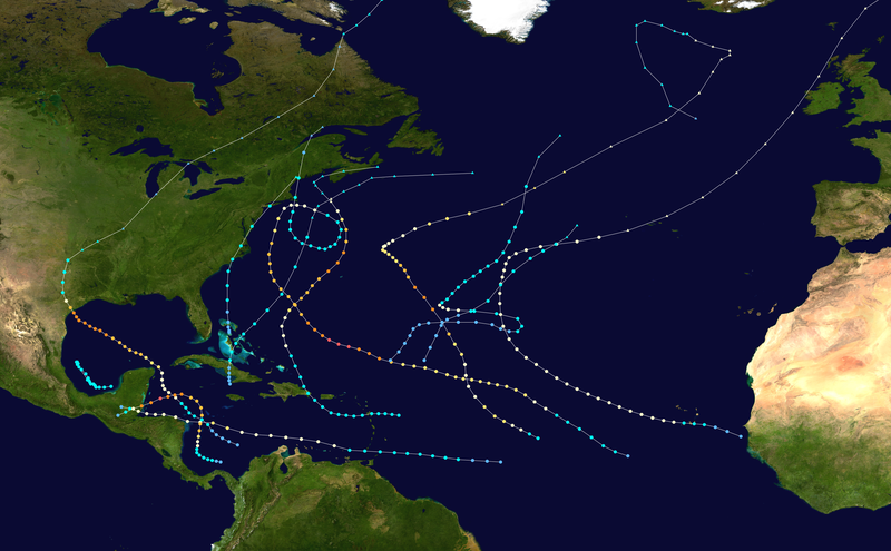
| Description1961 Atlantic hurricane season summary map.png | English: This map shows the tracks of all tropical cyclones in the 1961 Atlantic hurricane season. The points show the location of each storm at 6-hour intervals. The colour represents the storm's maximum sustained wind speeds as classified in the Saffir-Simpson Hurricane Scale (see below), and the shape of the data points represent the type of the storm.
| |||||||||||||||||||||||||||||||||||||||||||||||||||||||
| Date | – | |||||||||||||||||||||||||||||||||||||||||||||||||||||||
| Source | Created using WikiProject Tropical cyclones/Tracks. The background image is from NASA [1]. The tracking data is from the National Hurricane Center's Atlantic hurricane database | |||||||||||||||||||||||||||||||||||||||||||||||||||||||
| Author | Supportstorm | |||||||||||||||||||||||||||||||||||||||||||||||||||||||
Licensing:
Public domainPublic domainfalsefalse |
| This work has been released into the public domain by its author, Supportstorm. This applies worldwide. In some countries this may not be legally possible; if so: Supportstorm grants anyone the right to use this work for any purpose, without any conditions, unless such conditions are required by law. Public domainPublic domainfalsefalse |
File history
Click on a date/time to view the file as it appeared at that time.
| Date/Time | Thumbnail | Dimensions | User | Comment | |
|---|---|---|---|---|---|
| current | 18:12, 9 June 2013 |  | 3,000 × 1,854 (3.68 MB) | Supportstorm | {{Hurricane season auto track map|start=|end=|source=ATL|type=hurricane|basin=Atlantic|year=1961|author=Supportstorm}} |
File usage
The following pages on the English Wikipedia link to this file (pages on other projects are not listed):
- 1961 Atlantic hurricane season
- Atlantic hurricane season
- Hurricane Anna (1961)
- Hurricane Carla
- Hurricane Debbie (1961)
- Hurricane Esther
- Hurricane Hattie
- Template:1961 Atlantic hurricane season buttons
(window.RLQ=window.RLQ||).push(function(){mw.config.set({"wgBackendResponseTime":252,"wgHostname":"mw1324"});});


