Abitain
Abitain
Jump to navigation
Jump to search
Abitain | |
|---|---|
Commune | |
 The road into Abitain | |
Location of Abitain | |
 Abitain Show map of France  Abitain Show map of Nouvelle-Aquitaine | |
| Coordinates: 43°25′16″N 0°59′17″W / 43.421°N 0.988°W / 43.421; -0.988Coordinates: 43°25′16″N 0°59′17″W / 43.421°N 0.988°W / 43.421; -0.988 | |
| Country | France |
| Region | Nouvelle-Aquitaine |
| Department | Pyrénées-Atlantiques |
| Arrondissement | Oloron-Sainte-Marie |
| Canton | Orthez et Terres des Gaves et du Sel |
| Intercommunality | Béarn des Gaves |
| Government | |
| • Mayor .mw-parser-output .nobold{font-weight:normal} (2014-2020) | Marc Seguin |
| Area 1 | 6.59 km2 (2.54 sq mi) |
| Population (2016)2 | 97 |
| • Density | 15/km2 (38/sq mi) |
| Time zone | UTC+01:00 (CET) |
| • Summer (DST) | UTC+02:00 (CEST) |
INSEE/Postal code | 64004 /64390 |
| Elevation | 28–136 m (92–446 ft) (avg. 62 m or 203 ft) |
1 French Land Register data, which excludes lakes, ponds, glaciers > 1 km2 (0.386 sq mi or 247 acres) and river estuaries. 2Population without double counting: residents of multiple communes (e.g., students and military personnel) only counted once. | |
Abitain is a French commune in the Pyrénées-Atlantiques department in the Nouvelle-Aquitaine region in southwestern France.
The inhabitants are known as Abitainois, or Abitaonoises.[1]
Contents
1 Geography
1.1 Location
1.2 Hydrography
1.3 Localities and hamlets[2]
1.4 Neighbouring Communes and Villages
2 Toponymy
3 History
4 Administration
4.1 Intercommunality
5 Population
6 Economy
7 Culture and Heritage
7.1 Civil heritage
7.2 Religious Heritage
8 Notable People linked to the Commune
9 See also
10 Notes
11 References
Geography[edit]
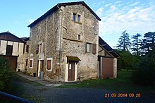
A House in Abitain
Location[edit]
Abitain is bordered on the eastern side by the Gave d'Oloron about 20 km southeast of Peyrehorade and 11 km southwest of Salies-de-Béarn. Access to the commune is by road D936 from Escos in the north, passing south down the eastern side of the commune through the village and continuing to Autevielle-Saint-Martin-Bideren in the south.
Hydrography[edit]
Located in the Drainage basin of the Adour, the commune's eastern border is the Gave d'Oloron, which joins the Gave de Pau at Peyrehorade which flows a further 10 km as the Gaves Réunis before joining the Adour river. A number of small streams flow in the commune including Le Crabé which flows into the Gave d'Oloron at the northern border of the commune and the Arrioutèque creek.
Localities and hamlets[2][edit]
- Aunès[3]
- Benes
- Le Bois
- Bonnefont[3]
- la Bordenave
- Constantine
- Coustalat
- Couyoula
- Dupont
- Etchebarne
- Labie
- Lafite[3]
- Lartigue
- Latéoulère
- le Lot
- Peyre
- Plain
- Pouey[3]
- Reyen
- Richard
- Ségabache
- Treyture
- La Tuilerie[3]
Neighbouring Communes and Villages[edit]
Places adjacent to Abitain | ||||||||||
|---|---|---|---|---|---|---|---|---|---|---|
| ||||||||||
Toponymy[edit]
The commune's name in Béarnais is Avitenh.
Michel Grosclaude proposed a Latin etymology of Avitus (name of a man called "Avit") plus the Gascon suffix -enh.[4]
The following table details the origins of the commune name and other names in the commune.
| Name | Spelling | Date | Source | Page | Origin | Description |
|---|---|---|---|---|---|---|
| Abitain | Bitengs | 13th century | Raymond | 2 | Bayonne | Village |
| Bitenh | 1385 | Raymond | 2 | Census | ||
| Abithen | 1439 | Raymond | 2 | Notaries | ||
| Sent-Pee d'Abitehn | 1472 | Raymond | 2 | Notaries | ||
| Havitenh | 1538 | Raymond | 2 | Reformation | ||
| Avitenh | 1546 | Raymond | 2 | Reformation | ||
| Aviteing | 1608 | Raymond | 2 | Insinuations | ||
| Avitein | 1786 | Raymond | 2 | Regulations | ||
| Abitain | 1750 | Cassini | ||||
| Aunès | l'ostau d'Ones | 1385 | Raymond | 17 | Census | Farm and Fief, Barony created in March 1775, vassal of the Viscounts of Béarn |
| La maison noble de Donez | 1666 | Raymond | 17 | Reformation | ||
| Omeix | 1666 | Raymond | 17 | Denombrement | ||
| Aunez | 1863 | Raymond | 17 | |||
| Bonnefont | Bonehont | 1385 | Raymond | 33 | Census | Fief, dependent on the Marquisate of Gassion |
| Bonafont | 1538 | Raymond | 33 | Reformation | ||
| Lafite | L'ostau de Lafite d'Abitenh | 1538 | Raymond | 89 | Reformation | Fief, dependent on the Viscounts of Béarn |
| Parlabriu | L'ostau de Part-l'Arriu d'Abitenh | 1385 | Raymond | 132 | Census | Farm and Fief, vassal of the Viscounts of Béarn and subject to the bailiwick of Sauveterre |
| Partarriu | 1546 | Raymond | 132 | Reformation | ||
| Pallarriu | 1778 | Raymond | 132 | Terrier | ||
| La Peyre | La Peyre | 1863 | Raymond | 134 | Census | Place |
| Pouey | Poey | 1755 | Raymond | 136 | Denombrement | Fief, vassal of the Viscounts of Béarn |
| Poey | 1863 | Raymond | 136 | |||
| La Tuilerie | La Teulere | 1537 | Raymond | 169 | Chapter | Fief |
| La Tuilerie | 1863 | Raymond | 169 |
Sources:
Raymond: Topographic Dictionary of the Department of Basses-Pyrenees, 1863, on the page numbers indicated in the table. (in French)[3]
Grosclaude: Toponymic Dictionary of communes, Béarn, 2006 (in French)[4]
Cassini: Cassini Map from 1750[5]
Origins:
Bayonne: Cartulary of Bayonne or Livre d'Or (Book of Gold)[6]
Census: Census of Béarn[7]
Notaries: Notaries of Labastide-Villefranche[8]
Reformation: Reformation of Béarn[9]
Insinuations: Insinuations of the Diocese of Oloron[10]
Regulations: Regulations of the States of Béarn[11](in French)
Denombrement: Denombremont[12]
Terrier: Terrier of Abitain.[13]
Chapter: Titles of the Chapter of Bayonne[14]
History[edit]
The village of Abitain formed on the left bank of the Gave d'Oloron around its Lay Abbey, vassal of the Viscounts of Bearn, a building which still remains.[3] The families of Belloc then Claverie were the abbot patrons of the parish. The tomb of the last lay abbot of Abitain, who died in 1785, is in the church of Saint-Pierre.
Paul Raymond, on page 2 of his 1863 dictionary, noted that in 1385 the town had 15 fires and depended on the bailiwick of Sauveterre.[3]
In 1648 the barony of Lons became a marquisate, which included Abitain, Anoye, Baleix, Castillon, Juillacq, Le Leu (hamlet Oraàs), Samsons-Lion, Lons, Maspie, Oraàs, Peyrède (fief Oraàs), Sauvagnon, and Viellepinte.[15]
The village had two mills: one at Leü (which actually depended on Oraàs) and one at Séguabache - now a sawmill.
In 1856, Ferdinand Carrère, heir to the last Lay Abbey demolished the old abbey castle to build Carrère castle in Escos.
In February 1814, the town was occupied by the troops of General Morillo and by the English, facing the French entrenched in Oraàs.
A famous ferry - where there was a tragic accident in 1845 - has long been in service between Moliède and Athos.
Administration[edit]
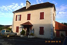
The Town Hall
List of Successive Mayors of Abitain[16]
| From | To | Name | Party | Position |
|---|---|---|---|---|
| 1935 | 1940 | Pierre de Chevigné | ||
| 1945 | 1965 | Pierre de Chevigné | MRP | |
| 1995 | 2001 | Denise Saint-Pé | UDF | |
| 2001 | 2008 | Victor Masero | DVD | |
| 2008 | 2014 | Didier Lasserre | ||
| 2014 | 2020 | Marc Seguin |
(Not all data is known)
Intercommunality[edit]
The town is a member of seven inter-communal organisations:
- the community of communes of Sauveterre-de-Béarn
- the Public agency for local management
- the inter-communal centre for social action of Sauveterre-de-Béarn;
- the intercommunal union of communal associations of Gave d'Oloron and Mauléon-Licharre
- the inter-communal union for Rivers and Lakes
- the AEP Union of Sauveterre-de-Béarn
- the Energy Union of Pyrénées-Atlantiques
Population[edit]
| Historical population | ||
|---|---|---|
| Year | Pop. | ±% |
| 2006 | 102 | — |
| 2007 | 102 | +0.0% |
| 2008 | 101 | −1.0% |
| 2009 | 101 | +0.0% |
| 2010 | 101 | +0.0% |
| 2011 | 99 | −2.0% |
| 2012 | 98 | −1.0% |
| 2013 | 96 | −2.0% |
| 2014 | 95 | −1.0% |
| 2015 | 93 | −2.1% |
| 2016 | 97 | +4.3% |
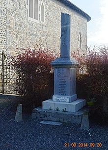
Abitain War Memorial
Economy[edit]
The activity of the commune is mainly agricultural. A sawmill is also in operation.
The town is part of the Appellation d'origine contrôlée (AOC) zone designation of Ossau-iraty.
Culture and Heritage[edit]
Civil heritage[edit]
There are only the ruins of the Leu mill which have been the subject of numerous lawsuits. Another mill, called Séguabache, is the current sawmill and is easily visible in the commune.
Religious Heritage[edit]

The Church of Saint Pierre
During the construction of the clock tower in 1926 what remained of the old lay abbey was destroyed. In the old abbey there was a special room where the Lord of the Manor could overlook the church choir and follow the Mass without being in the crowd. The abbey enclosure can still be seen.
The Tombstone of the last lord of Abitain was discovered during the restoration of the church. It was marked on the wall of the church to preserve its memory.
The Parish Church of Saint Pierre (19th century),![]() [17] of Romanesque origin, still has the arms of the Abitain abbots (Blason: Azure, with two stars Or in chief) from the burial of the last abbot. There is a 16th-century window of Germanic origin. Also in the church (in the attic) is an altarpiece from the 17th century.
[17] of Romanesque origin, still has the arms of the Abitain abbots (Blason: Azure, with two stars Or in chief) from the burial of the last abbot. There is a 16th-century window of Germanic origin. Also in the church (in the attic) is an altarpiece from the 17th century.
The Cemetery contains the graves of priests and that of Father Joffre, Capuchin missionary in Canada who died at Abitain in 1909. There is also the tomb of Colonel Count Pierre de Chevigne, Companion of the Liberation, one of the greats of béarnaise politics and a strong and faithful supporter of General de Gaulle. The coat of arms of Chevigne are engraved on his tomb with the motto "Quod decet". He donated land and equipment to the communes of Abitain and Escos.
Notable People linked to the Commune[edit]
Pierre de Chevigné, born in Toulon in 1909 and died in Biarritz in 2004 was a colonel and French politician, a Minister in the Fourth Republic and a companion of the Liberation. He was mayor of Abitain from 1935 to 1940 and from 1945 to 1965.
See also[edit]
- Communes of the Pyrénées-Atlantiques department
Notes[edit]
References[edit]
^ Inhabitants of Pyrénées-Atlantiques (in French)
^ Abitain on Géoportail, National Geographic Institute (IGN) website (in French)
^ abcdefgh Topographic Dictionary of the Department of Basses-Pyrenees, Paul Raymond, Imprimerie nationale, 1863, Digitised from Lyon Public Library 15 June 2011 (in French)
^ ab Michel Grosclaude, Toponymic Dictionary of communes, Béarn, Edicions reclams & Édition Cairn - 2006, 416 pages, .mw-parser-output cite.citation{font-style:inherit}.mw-parser-output q{quotes:"""""""'""'"}.mw-parser-output code.cs1-code{color:inherit;background:inherit;border:inherit;padding:inherit}.mw-parser-output .cs1-lock-free a{background:url("//upload.wikimedia.org/wikipedia/commons/thumb/6/65/Lock-green.svg/9px-Lock-green.svg.png")no-repeat;background-position:right .1em center}.mw-parser-output .cs1-lock-limited a,.mw-parser-output .cs1-lock-registration a{background:url("//upload.wikimedia.org/wikipedia/commons/thumb/d/d6/Lock-gray-alt-2.svg/9px-Lock-gray-alt-2.svg.png")no-repeat;background-position:right .1em center}.mw-parser-output .cs1-lock-subscription a{background:url("//upload.wikimedia.org/wikipedia/commons/thumb/a/aa/Lock-red-alt-2.svg/9px-Lock-red-alt-2.svg.png")no-repeat;background-position:right .1em center}.mw-parser-output .cs1-subscription,.mw-parser-output .cs1-registration{color:#555}.mw-parser-output .cs1-subscription span,.mw-parser-output .cs1-registration span{border-bottom:1px dotted;cursor:help}.mw-parser-output .cs1-hidden-error{display:none;font-size:100%}.mw-parser-output .cs1-visible-error{font-size:100%}.mw-parser-output .cs1-subscription,.mw-parser-output .cs1-registration,.mw-parser-output .cs1-format{font-size:95%}.mw-parser-output .cs1-kern-left,.mw-parser-output .cs1-kern-wl-left{padding-left:0.2em}.mw-parser-output .cs1-kern-right,.mw-parser-output .cs1-kern-wl-right{padding-right:0.2em}
ISBN 2-35068-005-3 (in French)
^ Cassini Map 1750 – Abitain
^ Manuscript from the 14th century in the Departmental Archives of Pyrénées-Atlantiques (in French)
^ Manuscript from the 14th century - Departmental Archives of Pyrénées-Atlantiques (in French)
^ Notaries of Labastide-Villefranche in the Departmental Archives of Pyrénées-Atlantiques (in French)
^ Manuscript from the 16th to 18th centuries - Departmental Archives of Pyrénées-Atlantiques (in French)
^ Manuscripts from the 17th century in the Departmental Archives of Pyrénées-Atlantiques (in French)
^ Manuscript Collection of 140 volumes of deliberations (1606 to 1789) in the Departmental Archives of Pyrénées-Atlantiques
^ Manuscripts from the 17th and 18th centuries in the Departmental Archives of Pyrénées-Atlantiques (in French)
^ Manuscript from the 18th century in the Departmental Archives of Pyrénées-Atlantiques (in French)
^ Chapter of Bayonne in the Departmental Archives of Pyrénées-Atlantiques (in French)
^ Topographic Dictionary of the Department of Basses-Pyrenees, p. 103
^ List of Mayors of France (in French)
^ Ministry of Culture, Mérimée IA64000666 Parish Church of Saint Pierre (in French)
| Wikimedia Commons has media related to Abitain. |
Communes of the Pyrénées-Atlantiques department | |
|---|---|
|
Categories:
- Communes of Pyrénées-Atlantiques
(window.RLQ=window.RLQ||).push(function(){mw.config.set({"wgPageParseReport":{"limitreport":{"cputime":"1.056","walltime":"1.284","ppvisitednodes":{"value":5533,"limit":1000000},"ppgeneratednodes":{"value":0,"limit":1500000},"postexpandincludesize":{"value":106785,"limit":2097152},"templateargumentsize":{"value":19568,"limit":2097152},"expansiondepth":{"value":26,"limit":40},"expensivefunctioncount":{"value":4,"limit":500},"unstrip-depth":{"value":1,"limit":20},"unstrip-size":{"value":11528,"limit":5000000},"entityaccesscount":{"value":1,"limit":400},"timingprofile":["100.00% 1022.193 1 -total"," 62.07% 634.497 1 Template:Infobox_French_commune"," 60.11% 614.391 1 Template:Infobox_settlement"," 49.09% 501.758 1 Template:Infobox"," 17.30% 176.854 17 Template:Fr_icon"," 17.05% 174.307 2 Template:Link_language"," 7.73% 79.004 1 Template:Reflist"," 5.77% 59.012 1 Template:Short_description"," 5.64% 57.608 1 Template:Commons_category"," 5.26% 53.732 2 Template:Infobox_mapframe"]},"scribunto":{"limitreport-timeusage":{"value":"0.547","limit":"10.000"},"limitreport-memusage":{"value":14707753,"limit":52428800}},"cachereport":{"origin":"mw1231","timestamp":"20190112023639","ttl":1900800,"transientcontent":false}}});});{"@context":"https://schema.org","@type":"Article","name":"Abitain","url":"https://en.wikipedia.org/wiki/Abitain","sameAs":"http://www.wikidata.org/entity/Q844039","mainEntity":"http://www.wikidata.org/entity/Q844039","author":{"@type":"Organization","name":"Contributors to Wikimedia projects"},"publisher":{"@type":"Organization","name":"Wikimedia Foundation, Inc.","logo":{"@type":"ImageObject","url":"https://www.wikimedia.org/static/images/wmf-hor-googpub.png"}},"datePublished":"2007-08-24T19:59:16Z","dateModified":"2019-01-12T02:36:39Z","image":"https://upload.wikimedia.org/wikipedia/commons/8/81/Abitain_Entry.JPG","headline":"commune in Pyru00e9nu00e9es-Atlantiques, France"}(window.RLQ=window.RLQ||).push(function(){mw.config.set({"wgBackendResponseTime":147,"wgHostname":"mw1264"});});


